GPS
Introduction
Global Positioning Systems (GPS) is a technology which allows a device to position itself anywhere on the planet where the sky is visible, typically to with a few metres of accuracy. GPS operates by using a network of satellites which broadcast very accurate timing information. By comparing the information from a number of senders, a GPS receiver is able to pinpoint its location.
The GPS system was built by the US Military and is still maintained by the at a cost of around US$750m per annum. However, it is free to use for commercial and private purposes. Initially the system included a built-in error to reduce accuracy to 100m. However this was turned off in the late 1990s as commercial use of the technology become more widespread.
A GPS receiver is a fairly sophisticated device. GPS signals are very weak and it takes a fair amount of processing to detect the signals and calculate positioning information from them. GPS does not work well indoors although it is possible to use a patch antenna on the roof. Despite this, Embedded GPS is becoming common with handheld devices, in-car-navigation devices and even cellphones.
Using positional information, a moving GPS-enabled device can also determine its speed and direction. A very accurate time is also provided as a side-effect of the technology (broadcast from the satellites). Therefore GPS is also used in applications which require a precise time or duration measurement, such as in the telecoms industry.

GPS Output
Typically, an embedded GPS receiver will output a serial string once per second (NMEA data) which includes time and positional information. This can be received and processed in software.
A fragment of data showing time (ZDA) and position (GLL) is shown below. This message is sent at 4800 baud (8N1) once per second.
$
MRK,0
ZDA,123336.8069,17,06,2001,13.0
GLL,2924.11158,N,1211.07392,W, 75.97,M
...
&
For more information on NMEA data see:
http://en.wikipedia.org/wiki/NMEA_0183
End User Applications
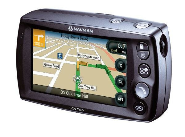
Originally used in military, aviation and maritime applications, consumer use of GPS is now widespread. Street-level navigation devices combine maps with a routing engine to offer street-level navigation which is now widely used in many countries. Examples of this kind of device include the Navman iCN750 which also integrates a digital camera and touchscreen. Navman's website has more details.
Bluewater Systems Experience
Bluewater has used embedded GPS technology in several projects including:
- Agricultural device for measuring and recording fertiliser use. This integrates a colour LCD screen, GPS, data storage, a wide range of I/O options and a Snapper 255 into a rugged enclosure (project name 'Roughy')

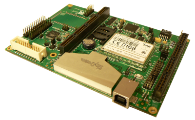
- Vehicle tracking device which integrates GPS, GPRS modem, Bluetooth, 1GB storage, a wide range of I/O options and Snapper CL15 into a tiny unit intended for vehicle mounted operation (project name 'Dory'). The GPS/GSM Telit module is visible in the upper left corner of the photo.

- High-end graphical agricultural device for mapping and data recording. This integrates a colour LCD screen, 3D graphics, GPS, data storage and many other features into a vehicle-mounted enclosure (project name 'Marlin').
See Location Tracking for more information.
GPS on Snapper / Rig 200
The Rig 200 Location Plus Module include GPS technology among other features. This connects to Rig 200 using the Module interface. The GPS function appears as a serial port accessible using standard Linux drivers and transmits time and position information regularly.
The embedded GPS module used on Rig 200 is made by Telit, an Italian manufacturer of GSM cellular modules and equipment. The module used on Rig 200 also has GSM quad band functionality to enable remote communication of positioning information with a central server.
In addition, the on-board micro can be used to provide the basis of a stand-alone tracking system. Example software is included which shows how to implement this.
In order to use GPS technology with Rig 200 you will need:
- Rig 200 base board
- Rig 200 Location Plus Module